
What is a subdivision plan?
Graphic document approved by the Ministry of Construction representing the division of land into plots, roads, public spaces, and planned facilities. It is the reference for identifying each plot.
Definition complete
The Subdivision Master Plan
The subdivision plan is a technical document that shows the layout of all plots, streets, and reserved spaces. It is prepared by a surveyor-urban planner and approved by the Ministry.
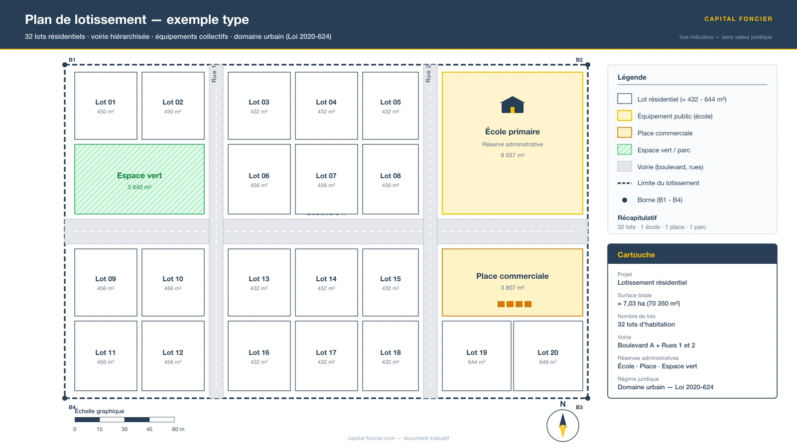
Illustrative view of an approved residential subdivision plan. Educational document, no legal value.
Reading the plan: a commented example
On the diagram above, four families of elements appear — the same that every approved subdivision plan must show:
- Numbered plots (Lot 01 to Lot 20) — each plot carries a unique number and a surface area in square metres. This numbering becomes the reference in every subsequent act: Final Concession Order (Arrêté de Concession Définitive — ACD), Land Title (Titre Foncier — TF) registered in the Land Book, sale contracts.
- Hierarchical road network — a structuring Boulevard and two secondary streets (Rues 1 and 2) serve each block. The width of the rights-of-way and the direction of traffic are set by the approval order.
- Administrative reserves — the school, the market square and the green space are land parcels that the developer transfers to the local authority. They can never be built on for private use.
- Boundary markers (B1 to B4) — the corners of the subdivision perimeter are materialised by geodetic boundary stones set by the surveyor. They legally fix the limits.
Information Contained
- Plot numbers and dimensions
- Layout of roads and sidewalks
- Reserved zones (schools, green spaces, etc.)
- Planned utilities (water, electricity, drainage)
Key takeaway
The subdivision plan shown above is a sample. Before any purchase, request the official plan approved by the Ministry of Construction, Housing and Urban Planning (MCLU) for your specific project, identify the exact number of the plot offered to you, and verify that its dimensions and location match the actual parcel on the ground. Water, electricity and drainage networks are documented in a separate VRD plan (Voirie et Réseaux Divers — Roads and Utility Networks), to be reviewed in addition.
Doctrinal note. ACD publication in the Land Registry: 180 official days (BÂTIR N°004, 2022), often longer in practice.
Besoin de conseils sur votre projet foncier ?
Nos experts vous accompagnent dans toutes les demarches.
Autres termes du glossaire
The ADU (Attestation de Droit d'Usage Coutumier / Customary Right of Use Certificate) is the single, secure document that replaces the former Village Certificate as of January 1, 2025. Established by Decree No. 2021-784 and secured by the SIGFU (Decree No. 2021-862), it requires a triple signature (village chief, CVGFR president, developer) and a unique IDUFCI. The ADU is not a property title: it constitutes a provisional recognition opening the path to the ACD (Arrêté de Concession Définitive / Definitive Concession Decree) — the ACD published in the Land Register IS the Land Title. In practice, the time between ACD signature and its publication in the Land Register is often longer than the official 180 calendar days (BÂTIR N°004, 2022). Published ACD = published Land Title — same legal deed, two stages.
The Rural Land Agency (AFOR — Agence Foncière Rurale) is the public institution responsible for implementing rural land policy in Ivory Coast. It oversees land certification, registration of rural properties, and coordination of boundary demarcation and surveying operations.
Legal document drafted by a notary that formalizes the transfer of land ownership between a seller and a buyer. The notarized deed of sale is mandatory and confers authenticity on the transaction.
Legal entity that must be established with a minimum share capital of 2 million FCFA held by Ivorian nationals, holding an approval from the Minister responsible for Housing and a financial guarantee from a bank or insurance company.
The alienation price is the sum that the buyer must pay to the State to obtain the Definitive Concession (ACD — Arrêté de Concession Définitive) of urban land. Calculated by an ad hoc commission, it corresponds to the market value of the parcel according to the official schedule.